Emesent’s Hovermap LHD has helped Byrnecut achieve near-real-time 3D stope hazard and volume assessments.
Load haul dump (LHD) machines, also known as scooptrams or boggers, are essential in underground mining operations, transporting ore and waste material from the mining face to designated dumping points.
While remote control and automation systems allow for safer operation, they also present challenges, particularly in low-visibility conditions common in underground mines.
Operators often rely on 2D cameras, which can provide a limited, poorly lit view, making it difficult to accurately assess the remaining material in a stope or detect geotechnical hazards like loose rocks and overhangs.
Limited visibility not only impacts productivity but also increases the risk of operational hazards, such as equipment damage or entrapment.
These risks can be particularly pronounced in cave-style mines, where LHDs are more likely to become trapped under falling rock.
The loss of equipment can halt ore extraction and lead to costly delays, with replacement machinery sometimes taking years to deliver.
Traditionally, cavity monitoring systems (CMS) have been used to measure stope volumes and assess hazards, but these systems require specialist training and are dependent on the availability of trained surveyors, typically only available during day shifts.
This can delay equipment planning decisions and potentially reduce productivity, especially when relocations need to occur outside of regular shift changes.
Recognising the potential for enhanced safety, productivity and cost savings, specialised underground mining contractor Byrnecut leveraged Emesent’s technology to implement an optimised bogging workflow in one of its sub-level caving operations.
The goal was to assess whether improved situational awareness through 3D data could help operators make faster, better decisions, ultimately enhancing both productivity and safety.
The solution
Emesent collaborated with global mining services provider Mining Plus to drive development of the solution, working with Byrnecut to understand its needs and test various options.
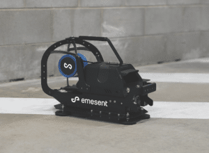
The result was Hovermap LHD, a system that utilises advanced simultaneous location and mapping (SLAM)-based light detection and ranging (LiDAR) scanning technology, offering a 300m range and a 360° field of view to capture and visualise survey-grade point clouds in the field.

Image: Emesent
The unit, which can be easily mounted onto the cab or bucket of an LHD using magnetic feet, connects to the mine’s network via the machine’s onboard Wi-Fi.
This setup enables remote operators to continuously scan and visualise a 360° point cloud of the entire stope, even in zero-light conditions, using a dedicated tablet.
This near-real-time data can enable the safe, fast and thorough identification of loose rocks, geotechnical hazards and hazardous rill angles that could potentially damage equipment.
Designed for simplicity, Hovermap LHD requires no specialist training, allowing non-surveyors to perform pickups 24–7. This capability enables quick identification of remaining stope volume and more effective planning of equipment allocation, which can significantly boost productivity.
Beyond LHD operations, Hovermap’s versatility sees it used in various configurations, including handheld, on a backpack, mounted on a drone, vehicle, ground robot, or CMS boom, or lowered into shafts in a cage.
This flexibility can expand Hovermap’s applications throughout a mine, potentially offering an even greater return on investment.
The results
The data captured by Hovermap LHD was able to dramatically reduce the time needed to identify hazards such as steep rill angles, oversized material, and confirm the stability of brows, walls, and crowns during remote bogging operations.
Areas that once took up to two days to scan and process can now be captured and visualised in just 10 minutes.
In a hypothetical copper-gold mining operation, an LHD getting stuck can result in one or two shifts of lost production, or even several days.
With Hovermap LHD, crews can perform scans underground at any time, which can lead to accelerated decision-making and minimised risk of damaging or burying an LHD.
This capability has also increased stope turnover, as underground crews can quickly assess an area and make rapid decisions on equipment relocation when the stope is clean.
After realising these benefits, Byrnecut decided to roll out Hovermap LHD to additional mine sites, further advancing its commitment to safety and productivity.
This feature appeared in the December 2024 issue of Australian Mining.


